Moissey
|
|---|
 |
|
Region
|
Bourgogne-Franche-Comté
|
Département
|
Jura
|
Arrondissement
|
Dole
|
Kanton
|
Authume
|
Gemeindeverband
|
Grand Dole
|
Koordinaten
|
47° 12′ N, 5° 31′ O47.1977777777785.5244444444444Koordinaten: 47° 12′ N, 5° 31′ O
|
Höhe
|
217–377 m
|
Fläche
|
10,63 km2 |
Einwohner
|
556 (1. Januar 2015)
|
Bevölkerungsdichte
|
52 Einw./km2 |
Postleitzahl
|
39290
|
INSEE-Code
|
39335
|

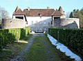
Die Mairie
|
Moissey ist eine französische Gemeinde im Département Jura in der Region Bourgogne-Franche-Comté. Sie gehört zum Arrondissement Dole und zum Kanton Authume.
Geografie |
Die Départementsstraße D475 verbindet Moissey mit Menotey im Südwesten und Offlanges im Nordosten. Die weiteren Nachbargemeinden sind Montmirey-la-Ville im Norden, Montmirey-le-Château im Nordosten, Amange im Südosten sowie Gredisans, Archelange und Châtenois im Süden.
Die Gemeindegemarkung hat Anteile am Mont Guérin im Osten und am Forêt de la Serre im Westen.
Bevölkerungsentwicklung |
1962
|
1968
|
1975
|
1982
|
1990
|
1999
|
2006
|
2014
|
|---|
| 367 |
340 |
346 |
381 |
426 |
527 |
559 |
552
|
Weblinks |
 Commons: Moissey
 – Sammlung von Bildern, Videos und Audiodateien
.mw-parser-output div.NavFrameborder:1px solid #A2A9B1;clear:both;font-size:95%;margin-top:1.5em;min-height:0;padding:2px;text-align:center.mw-parser-output div.NavPicfloat:left;padding:2px.mw-parser-output div.NavHeadbackground-color:#EAECF0;font-weight:bold.mw-parser-output div.NavFrame:afterclear:both;content:"";display:block.mw-parser-output div.NavFrame+div.NavFrame,.mw-parser-output div.NavFrame+link+div.NavFramemargin-top:-1px.mw-parser-output .NavTogglefloat:right;font-size:x-small
Gemeinden im Arrondissement Dole
Abergement-la-Ronce |
Abergement-le-Grand |
Abergement-le-Petit |
Abergement-lès-Thésy |
Aiglepierre |
Amange |
Annoire |
Arbois |
Archelange |
Aresches |
Asnans-Beauvoisin |
Audelange |
Augerans |
Aumont |
Aumur |
Authume |
Auxange |
Balaiseaux |
Bans |
Barretaine |
Baverans |
Belmont |
Bersaillin |
Besain |
Biarne |
Biefmorin |
Bracon |
Brainans |
Brans |
Bretenières |
Brevans |
Buvilly |
Cernans |
Chaînée-des-Coupis |
Chamblay |
Chamole |
Champagne-sur-Loue |
Champagney |
Champdivers |
Champvans |
Chatelay |
Châtenois |
Chaussenans |
Chaussin |
Chaux-Champagny |
Chemin |
Chêne-Bernard |
Chevigny |
Chilly-sur-Salins |
Chissey-sur-Loue |
Choisey |
Clucy |
Colonne |
Courtefontaine |
Cramans |
Crissey |
Dammartin-Marpain |
Damparis |
Dampierre |
Darbonnay |
Dole |
Dournon |
Éclans-Nenon |
Écleux |
Étrepigney |
Évans |
Falletans |
Fay-en-Montagne |
Foucherans |
Fraisans |
Frasne-les-Meulières |
Gatey |
Gendrey |
Geraise |
Germigney |
Gevry |
Grange-de-Vaivre |
Gredisans |
Grozon |
Ivory |
Ivrey |
Jouhe |
La Barre |
La Bretenière |
La Chapelle-sur-Furieuse |
La Châtelaine |
La Ferté |
La Loye |
La Vieille-Loye |
Lavangeot |
Lavans-lès-Dole |
Le Chateley |
Le Deschaux |
Le Fied |
Le Petit-Mercey |
Lemuy |
Les Arsures |
Les Essards-Taignevaux |
Les Hays |
Les Planches-près-Arbois |
Longwy-sur-le-Doubs |
Louvatange |
Malange |
Marnoz |
Mathenay |
Menotey |
Mesnay |
Miéry |
Moissey |
Molain |
Molamboz |
Molay |
Monay |
Monnières |
Montbarrey |
Monteplain |
Montholier |
Montigny-lès-Arsures |
Montmarlon |
Montmirey-la-Ville |
Montmirey-le-Château |
Mont-sous-Vaudrey |
Mouchard |
Mutigney |
Neublans-Abergement |
Neuvilley |
Nevy-lès-Dole |
Offlanges |
Orchamps |
Ougney |
Ounans |
Our |
Oussières |
Pagney |
Pagnoz |
Parcey |
Peintre |
Peseux |
Petit-Noir |
Picarreau |
Plasne |
Pleure |
Plumont |
Pointre |
Poligny |
Pont-d’Héry |
Port-Lesney |
Pretin |
Pupillin |
Rahon |
Rainans |
Ranchot |
Rans |
Rochefort-sur-Nenon |
Romain |
Romange |
Rouffange |
Saint-Aubin |
Saint-Baraing |
Saint-Cyr-Montmalin |
Saint-Lothain |
Saint-Loup |
Saint-Thiébaud |
Saizenay |
Salans |
Saligney |
Salins-les-Bains |
Sampans |
Santans |
Séligney |
Sermange |
Serre-les-Moulières |
Souvans |
Tassenières |
Tavaux |
Taxenne |
Thervay |
Thésy |
Tourmont |
Vadans |
Vaudrey |
Vaux-sur-Poligny |
Villeneuve-d’Aval |
Villerserine |
Villers-Farlay |
Villers-les-Bois |
Villers-Robert |
Villette-lès-Arbois |
Villette-lès-Dole |
Vitreux |
Vriange